Colombia Volcanoes
-
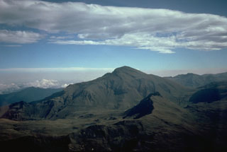
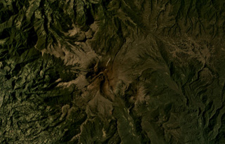
Nevado del Huila
-
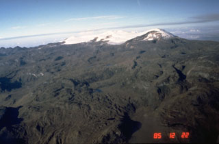
Nevado del Ruiz
-

Nevado del Ruiz
-
Nevado del Ruiz
-
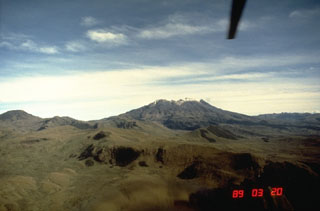
Nevado del Ruiz
-
Cumbal
-

Nevado del Ruiz
-
Azufral
-
Azufral
-
Azufral
-

Cerro Bravo
-

Chiles-Cerro Negro
-
Nevado del Tolima
-
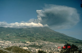
Galeras
-

Machin
-

Nevado del Huila
-
Purace
-
Machin
-

Machin
-
Nevado del Huila
Colombia has 14 Holocene volcanoes. Note that as a scientific organization we provide these listings for informational purposes only, with no international legal or policy implications. Volcanoes will be included on this list if they are within the boundaries of a country, on a shared boundary or area, in a remote territory, or within a maritime Exclusive Economic Zone. Bolded volcanoes have erupted within the past 20 years. Suggestions and data updates are always welcome ().
| Volcano Name | Location | Last Eruption | Primary Volcano Type |
|---|---|---|---|
| Azufral | Colombia | 930 BCE | Stratovolcano |
| Cerro Bravo | Colombia | 1720 CE | Stratovolcano |
| Chiles-Cerro Negro | Colombia-Ecuador | 1936 CE | Stratovolcano |
| Cumbal | Colombia | 1926 CE | Stratovolcano |
| Dona Juana | Colombia | 1906 CE | Stratovolcano |
| Galeras | Colombia | 2014 CE | Complex |
| Nevado del Huila | Colombia | 2012 CE | Stratovolcano |
| Machin | Colombia | 1180 CE | Stratovolcano |
| Purace | Colombia | 2023 CE | Stratovolcano(es) |
| Romeral | Colombia | 5390 BCE | Stratovolcano |
| Nevado del Ruiz | Colombia | 2024 CE | Stratovolcano |
| Santa Isabel | Colombia | 850 BCE | Shield |
| Sotara | Colombia | Unknown - Evidence Credible | Stratovolcano |
| Nevado del Tolima | Colombia | 1943 CE | Stratovolcano |
Chronological listing of known Holocene eruptions (confirmed or uncertain) from volcanoes in Colombia. Bolded eruptions indicate continuing activity.
| Volcano Name | Start Date | Stop Date | Certainty | VEI | Evidence |
|---|---|---|---|---|---|
| Purace | 2023 Nov 16 | 2023 Nov 16 | Confirmed | Observations: Reported | |
| Purace | 2022 Mar 29 | 2022 Mar 29 | Confirmed | 1 | Observations: Reported |
| Nevado del Ruiz | 2014 Nov 18 | 2024 Apr 19 (continuing) | Confirmed | 2 | Observations: Reported |
| Galeras | 2012 May 13 | 2014 Jan 30 ± 1 days | Confirmed | 2 | Observations: Reported |
| Nevado del Ruiz | 2012 Feb 22 | 2013 Jul 12 (?) | Confirmed | 3 | Observations: Reported |
| Galeras | [2011 Mar 31] | [2011 Apr 1] | Uncertain | ||
| Galeras | 2010 Aug 25 | 2010 Aug 25 | Confirmed | 2 | Observations: Reported |
| Nevado del Huila | 2008 Oct 26 (?) | 2012 Jan 14 (?) | Confirmed | 3 | Observations: Reported |
| Galeras | 2008 Oct 21 (?) | 2010 Jan 2 (?) | Confirmed | 3 | Observations: Reported |
| Nevado del Huila | 2008 Jan 2 | 2008 Apr 16 (?) ± 15 days | Confirmed | 2 | Observations: Reported |
| Galeras | 2007 Oct 4 | 2008 Jan 17 | Confirmed | 3 | Observations: Reported |
| Nevado del Huila | 2007 Feb 19 | 2007 May 28 (?) | Confirmed | 3 | Observations: Reported |
| Galeras | 2005 Nov 24 | 2006 Jul 12 | Confirmed | 2 | Observations: Reported |
| Galeras | 2004 Jul 16 | 2005 Feb 7 (?) | Confirmed | 3 | Observations: Reported |
| Galeras | 2002 Jun 7 | 2002 Jun 7 (?) | Confirmed | 1 | Observations: Reported |
| Galeras | 2000 Mar 21 | 2000 May 18 | Confirmed | 1 | Observations: Reported |
| Nevado del Ruiz | [1994 Apr 23] | [1994 Apr 23] | Uncertain | ||
| Galeras | 1993 Jan 14 | 1993 Jun 7 | Confirmed | 2 | Observations: Reported |
| Galeras | 1990 Jan 7 | 1992 Jul 16 | Confirmed | 2 | Observations: Reported |
| Galeras | 1989 Feb 19 | 1989 May 9 | Confirmed | 2 | Observations: Reported |
| Nevado del Ruiz | 1985 Sep 11 | 1991 Jul 13 | Confirmed | 3 | Observations: Reported |
| Nevado del Ruiz | 1984 Dec 22 | 1985 Mar 19 (?) | Confirmed | 1 | Observations: Reported |
| Purace | 1977 Mar 19 | 1977 Mar 28 (?) | Confirmed | 2 | Observations: Reported |
| Galeras | 1974 Jul 2 ± 182 days | 1983 Jul 2 (?) ± 182 days | Confirmed | 1 | Observations: Reported |
| Galeras | [1973 May 16 ± 15 days] | [Unknown] | Uncertain | ||
| Purace | 1957 Jul 2 ± 182 days | Unknown | Confirmed | 2 | Observations: Reported |
| Purace | 1956 Jul 2 (in or before) ± 182 days | Unknown | Confirmed | 2 | Observations: Reported |
| Galeras | 1950 Jan 12 | 1950 Sep 5 | Confirmed | 2 | Observations: Reported |
| Purace | 1949 May 26 | 1949 Jun 11 | Confirmed | 2 | Observations: Reported |
| Galeras | [1947 Jul 15] | [Unknown] | Uncertain | ||
| Purace | 1947 Apr 27 | Unknown | Confirmed | 2 | Observations: Reported |
| Purace | 1946 Mar | 1946 Apr | Confirmed | 2 | Observations: Reported |
| Nevado del Tolima | 1943 Mar | Unknown | Confirmed | 2 | Observations: Reported |
| Chiles-Cerro Negro | 1936 Jul 17 | Unknown | Confirmed | 2 | Observations: Reported |
| Galeras | 1936 Feb 9 | 1936 Aug 27 (?) | Confirmed | 2 | Observations: Reported |
| Galeras | [1933] | [Unknown] | Uncertain | ||
| Galeras | 1932 Oct 10 | Unknown | Confirmed | 2 | Observations: Reported |
| Galeras | [1930 Apr 17] | [Unknown] | Uncertain | ||
| Purace | 1927 | Unknown | Confirmed | 2 | Observations: Reported |
| Cumbal | 1926 Dec 20 | 1926 Dec 21 | Confirmed | 2 | Observations: Reported |
| Purace | 1926 Aug | 1926 Sep | Confirmed | 2 | Observations: Reported |
| Purace | 1925 Oct 12 | 1925 Nov 5 | Confirmed | 2 | Observations: Reported |
| Galeras | 1924 Oct | 1927 | Confirmed | 3 | Observations: Reported |
| Purace | 1924 | Unknown | Confirmed | 2 | Observations: Reported |
| Galeras | 1923 Dec 8 | Unknown | Confirmed | 2 | Observations: Reported |
| Nevado del Ruiz | 1916 | Unknown | Confirmed | 2 | Observations: Reported |
| Purace | 1906 | Unknown | Confirmed | 2 | Observations: Reported |
| Purace | 1902 (?) | Unknown | Confirmed | 2 | Observations: Reported |
| Purace | 1899 | Unknown | Confirmed | 2 | Observations: Reported |
| Dona Juana | 1897 Nov 1 | 1906 | Confirmed | 4 | Observations: Reported |
| Galeras | 1891 | Unknown | Confirmed | 2 | Observations: Reported |
| Galeras | 1889 Jul 3 | Unknown | Confirmed | 2 | Observations: Reported |
| Purace | 1885 May 25 | Unknown | Confirmed | 3 | Observations: Reported |
| Purace | 1881 | Unknown | Confirmed | 2 | Observations: Reported |
| Purace | 1878 Aug 31 | Unknown | Confirmed | 2 | Observations: Reported |
| Cumbal | 1877 Dec | Unknown | Confirmed | 2 | Observations: Reported |
| Purace | 1870 Oct | Unknown | Confirmed | 2 | Observations: Reported |
| Purace | 1869 Oct 4 | 1869 Nov | Confirmed | 3 | Observations: Reported |
| Galeras | 1865 Oct 2 | 1870 | Confirmed | 3 | Observations: Reported |
| Purace | 1860 ± 9 years | Unknown | Confirmed | 2 | Observations: Reported |
| Purace | 1847 Oct 27 | 1852 | Confirmed | 3 | Observations: Reported |
| Nevado del Ruiz | 1845 Feb 19 | Unknown | Confirmed | 3 | Observations: Reported |
| Purace | 1840 | Unknown | Confirmed | 2 | Observations: Reported |
| Galeras | [1836] | [Unknown] | Uncertain | ||
| Purace | 1835 Jan 23 | Unknown | Confirmed | 2 | Observations: Reported |
| Galeras | 1834 | Unknown | Confirmed | 2 | Observations: Reported |
| Nevado del Ruiz | [1833] | [Unknown] | Uncertain | ||
| Nevado del Ruiz | 1831 | Unknown | Confirmed | 2 | Observations: Reported |
| Nevado del Ruiz | 1829 Jun 18 | Unknown | Confirmed | 2 | Observations: Reported |
| Galeras | 1828 Oct 24 | 1834 Mar | Confirmed | 3 | Observations: Reported |
| Nevado del Ruiz | 1828 Jun | Unknown | Confirmed | 2 | Observations: Reported |
| Purace | 1827 Nov 18 | Unknown | Confirmed | 2 | Observations: Reported |
| Nevado del Tolima | 1826 May | 1826 Jun 17 (in or after) | Confirmed | 2 | Observations: Reported |
| Nevado del Ruiz | [1826] | [Unknown] | Uncertain | ||
| Nevado del Tolima | 1825 Mar 2 (?) | Unknown | Confirmed | 2 | Observations: Reported |
| Galeras | 1823 Jun 17 | 1823 Jun 24 | Confirmed | 2 | Observations: Reported |
| Nevado del Tolima | 1822 Nov (?) | Unknown | Confirmed | 2 | Observations: Reported |
| Purace | 1816 | Unknown | Confirmed | Observations: Reported | |
| Nevado del Ruiz | 1805 Mar 14 | Unknown | Confirmed | 2 | Observations: Reported |
| Galeras | 1796 Nov | 1801 | Confirmed | 2 | Observations: Reported |
| Galeras | 1754 | 1756 | Confirmed | 2 | Observations: Reported |
| Cerro Bravo | 1720 ± 150 years | Unknown | Confirmed | 4 | Correlation: Tephrochronology |
| Galeras | 1670 | 1736 | Confirmed | 3 | Observations: Reported |
| Galeras | 1641 | 1643 | Confirmed | 3 | Observations: Reported |
| Nevado del Ruiz | 1623 | Unknown | Confirmed | 1 | Observations: Reported |
| Galeras | 1616 Jul 4 | 1616 Jul 4 | Confirmed | 3 | Observations: Reported |
| Nevado del Ruiz | 1595 Mar 9 (in or before) | Unknown | Confirmed | 4 | Observations: Reported |
| Galeras | 1580 Dec 7 | 1580 Dec 7 | Confirmed | 3 | Observations: Reported |
| Nevado del Ruiz | 1570 | Unknown | Confirmed | Observations: Reported | |
| Nevado del Huila | 1555 ± 5 years | Unknown | Confirmed | Observations: Reported | |
| Nevado del Ruiz | [1541] | [Unknown] | Uncertain | ||
| Galeras | 1535 | Unknown | Confirmed | 3 | Observations: Reported |
| Nevado del Ruiz | 1350 (?) | Unknown | Confirmed | 4 | Isotopic: 14C (uncalibrated) |
| Cerro Bravo | 1330 ± 75 years | Unknown | Confirmed | 4 | Isotopic: 14C (uncalibrated) |
| Machin | 1180 ± 150 years | Unknown | Confirmed | Isotopic: 14C (calibrated) | |
| Cerro Bravo | 1050 ± 75 years | Unknown | Confirmed | 4 | Isotopic: 14C (uncalibrated) |
| Galeras | 0890 ± 200 years | Unknown | Confirmed | 2 | Isotopic: 14C (calibrated) |
| Machin | 0750 (?) | Unknown | Confirmed | Isotopic: 14C (uncalibrated) | |
| Cerro Bravo | 0750 ± 150 years | Unknown | Confirmed | 4 | Isotopic: 14C (uncalibrated) |
| Nevado del Ruiz | 0675 ± 50 years | Unknown | Confirmed | 3 | Isotopic: 14C (uncalibrated) |
| Nevado del Ruiz | 0350 ± 300 years | Unknown | Confirmed | 3 | Isotopic: 14C (uncalibrated) |
| Nevado del Tolima | 0260 ± 150 years | Unknown | Confirmed | 3 | Isotopic: 14C (calibrated) |
| Purace | 0160 BCE ± 50 years | Unknown | Confirmed | Isotopic: 14C (uncalibrated) | |
| Nevado del Tolima | 0200 BCE ± 200 years | Unknown | Confirmed | 3 | Isotopic: 14C (calibrated) |
| Nevado del Ruiz | 0200 BCE ± 100 years | Unknown | Confirmed | 4 | Isotopic: 14C (uncalibrated) |
| Galeras | 0490 BCE ± 100 years | Unknown | Confirmed | 2 | Isotopic: 14C (calibrated) |
| Nevado del Tolima | 0610 BCE ± 200 years | Unknown | Confirmed | 3 | Isotopic: 14C (calibrated) |
| Machin | 0650 BCE (?) | Unknown | Confirmed | Isotopic: 14C (uncalibrated) | |
| Cerro Bravo | 0730 BCE ± 75 years | Unknown | Confirmed | 4 | Isotopic: 14C (uncalibrated) |
| Nevado del Ruiz | 0850 BCE (?) | Unknown | Confirmed | 4 | Correlation: Tephrochronology |
| Santa Isabel | 0850 BCE (?) | Unknown | Confirmed | Isotopic: 14C (calibrated) | |
| Azufral | 0930 BCE (?) | Unknown | Confirmed | 4 | Isotopic: 14C (uncalibrated) |
| Cerro Bravo | 1050 BCE ± 200 years | Unknown | Confirmed | 4 | Correlation: Tephrochronology |
| Galeras | 1160 BCE ± 300 years | Unknown | Confirmed | 2 | Isotopic: 14C (calibrated) |
| Nevado del Ruiz | 1245 BCE ± 150 years | Unknown | Confirmed | Isotopic: 14C (uncalibrated) | |
| Cerro Bravo | 1310 BCE ± 150 years | Unknown | Confirmed | 4 | Isotopic: 14C (uncalibrated) |
| Azufral | 1650 BCE ± 150 years | Unknown | Confirmed | Isotopic: 14C (uncalibrated) | |
| Azufral | 1850 BCE (?) | Unknown | Confirmed | Isotopic: 14C (uncalibrated) | |
| Nevado del Tolima | 1990 BCE ± 200 years | Unknown | Confirmed | 5 | Isotopic: 14C (calibrated) |
| Azufral | 2095 BCE ± 100 years | Unknown | Confirmed | Isotopic: 14C (uncalibrated) | |
| Machin | 2100 BCE ± 200 years | Unknown | Confirmed | Isotopic: 14C (calibrated) | |
| Machin | 2240 BCE ± 300 years | Unknown | Confirmed | Isotopic: 14C (calibrated) | |
| Dona Juana | 2550 BCE ± 150 years | Unknown | Confirmed | 4 | Isotopic: 14C (uncalibrated) |
| Galeras | 2580 BCE ± 500 years | Unknown | Confirmed | 2 | Isotopic: 14C (calibrated) |
| Machin | 2650 BCE (?) | Unknown | Confirmed | Isotopic: 14C (uncalibrated) | |
| Galeras | 3150 BCE ± 200 years | Unknown | Confirmed | 3 | Isotopic: 14C (calibrated) |
| Nevado del Tolima | 3500 BCE ± 300 years | Unknown | Confirmed | Isotopic: 14C (calibrated) | |
| Santa Isabel | 3550 BCE (?) | Unknown | Confirmed | Isotopic: 14C (calibrated) | |
| Machin | 3800 BCE ± 150 years | Unknown | Confirmed | Isotopic: 14C (calibrated) | |
| Cerro Bravo | 4280 BCE ± 150 years | Unknown | Confirmed | 4 | Isotopic: 14C (uncalibrated) |
| Santa Isabel | 4800 BCE (?) | Unknown | Confirmed | Isotopic: 14C (calibrated) | |
| Nevado del Tolima | 5160 BCE ± 200 years | Unknown | Confirmed | Isotopic: 14C (calibrated) | |
| Nevado del Tolima | 5310 BCE ± 100 years | Unknown | Confirmed | Isotopic: 14C (uncalibrated) | |
| Romeral | 5390 BCE ± 350 years | Unknown | Confirmed | 4 | Isotopic: 14C (uncalibrated) |
| Santa Isabel | 5500 BCE (?) | Unknown | Confirmed | Isotopic: 14C (calibrated) | |
| Romeral | 6510 BCE ± 200 years | Unknown | Confirmed | 4 | Isotopic: 14C (uncalibrated) |
| Nevado del Ruiz | 6660 BCE (in or before) | Unknown | Confirmed | Correlation: Tephrochronology | |
| Galeras | 7050 BCE ± 1000 years | Unknown | Confirmed | Correlation: Tephrochronology | |
| Nevado del Tolima | 7800 BCE ± 300 years | Unknown | Confirmed | 4 | Isotopic: 14C (uncalibrated) |
Colombia has 9 Pleistocene volcanoes. Note that as a scientific organization we provide these listings for informational purposes only, with no international legal or policy implications. Volcanoes will be included on this list if they are within the boundaries of a country, on a shared boundary or area, in a remote territory, or within a maritime Exclusive Economic Zone. Suggestions and data updates are always welcome ().
| Volcano Name | Location | Primary Volcano Type |
|---|---|---|
| Animas | Colombia | Stratovolcano |
| Cutanga | Colombia | Unknown |
| El Escondido | Colombia | Lava dome |
| Petacas | Colombia | Lava dome |
| Nevado del Quindio | Colombia | Stratovolcano |
| San Augustín-Isnos | Colombia | Volcanic field |
| San Diego | Samana Volcanic Field | Maar |
| Santa Rosa | Colombia | Shield |
| Unnamed | Colombia | Volcanic field |
There are 35 photos available for volcanoes in Colombia.
 Cerro Bravo is seen from the east. The summit dome was extruded during the most recent eruption and has a spine (a steep dome) near the top. An older lava dome and cone complex is situated to the left. Multiple collapse events sent block-and-ash flows down over lava flows (center) and onto the Plan de Arriba (lower left). The low tree-covered slope (left foreground) is the remnant of the pre-Cerro Bravo edifice that was destroyed by a Pleistocene caldera-forming event.
Photo by David Lescinsky, 1988 (University of Western Ontario).
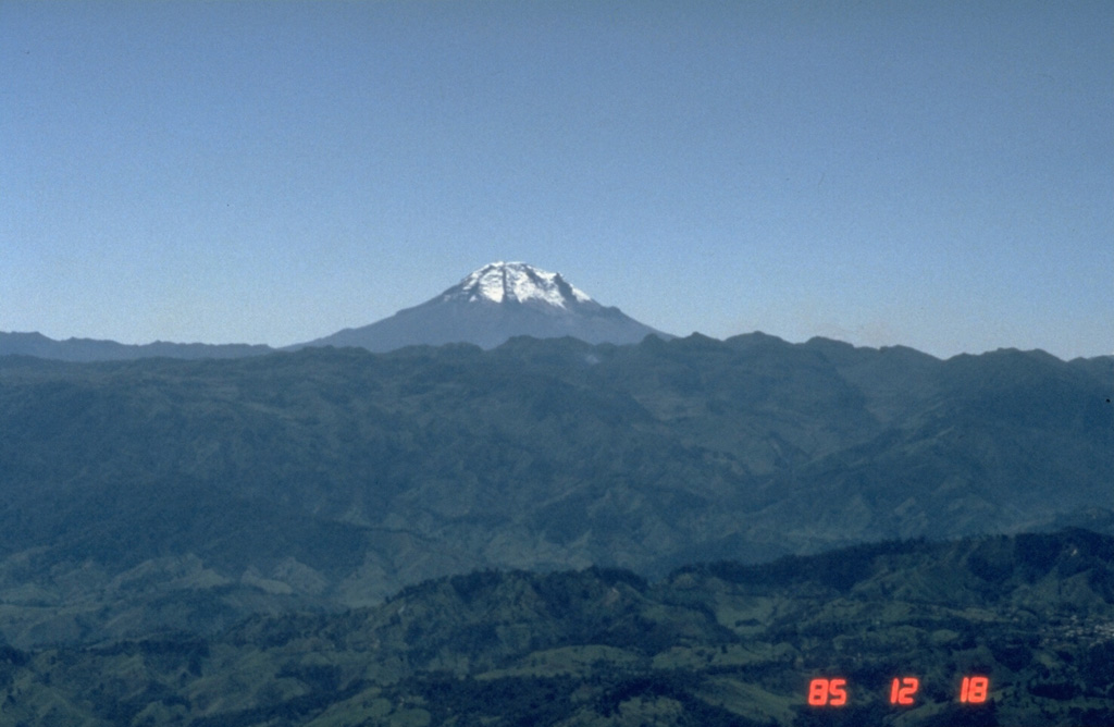
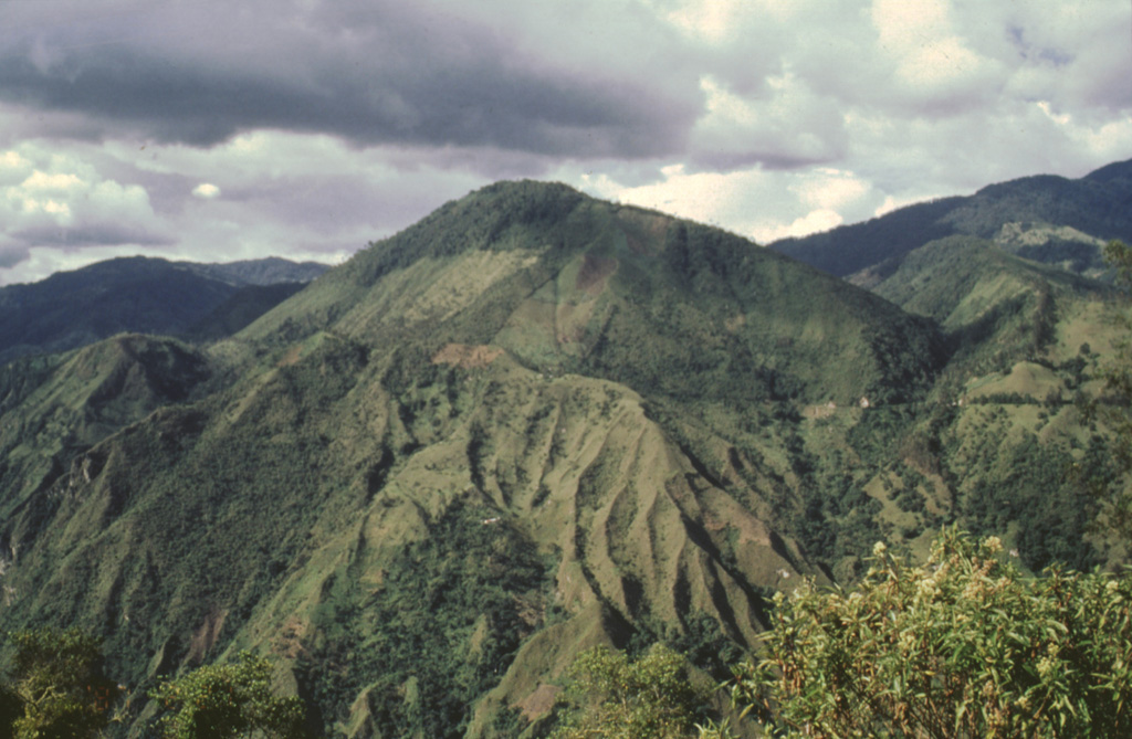
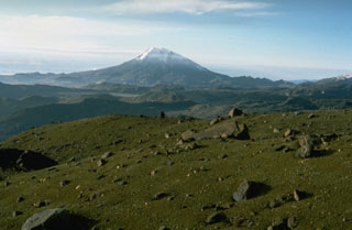
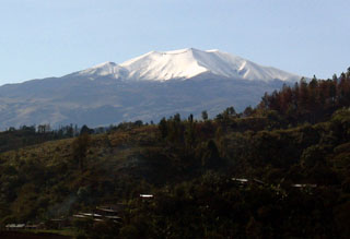
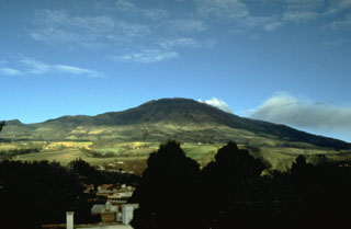
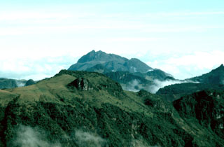
 Nevado del Tolima rises to the south above the forested mountains of the Central Cordillera of Colombia. The summit consists of a late-Pleistocene to Holocene lava domes that were associated with thick lava flows and extensive pyroclastic flow deposits. A major eruption took place about 3,600 years ago and moderate historical eruptions have occurred in the 19th and 20th centuries.
 Photo by Norm Banks, 1895 (U.S. Geological Survey).
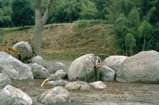 A cluster of rounded boulders was deposited on a river terrace by a lahar in the Río Chinchina valley, 59 km WNW of the summit of Colombia's Nevado del Ruiz volcano on 13 November 1985. The boulders were carried within the lahar and deposited against the tree that served as an obstruction to flow. Note the mudline on the tree that marks the upper flow surface of the lahar.
Photo by Tom Pierson, 1985 (U.S. Geological Survey).
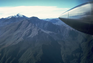
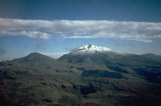
 Glaciated Tolima volcano is seen here looking south from the flank of Nevado del Ruiz. The summit consists of late-Pleistocene to Holocene lava domes and contains a crater 200-300 m deep. Holocene activity has ranged from moderate explosions to Plinian eruptions. A recent major eruption took place about 3,600 years ago and minor explosive eruptions took place in the 19th and 20th centuries.
Photo by Tom Pierson, 1985 (U.S. Geological Survey).
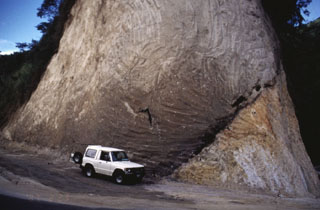 A road cut exposes a pyroclastic flow deposit (left) overlying older granite (lower right). The dark zone dipping away from the front of the jeep, at the base of the pyroclastic flow deposit, are trees charred by the hot pyroclastic flow. This site is located along the road that connects the cities of Ibague and Cajamarco, close to the town of El Boqueron, about 12 km from Cerro Machín volcano.
Photo by José Macías, 1996 (Universidad Autómona de México).
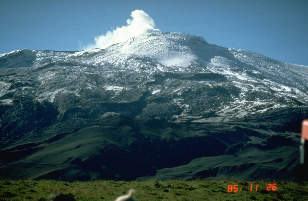
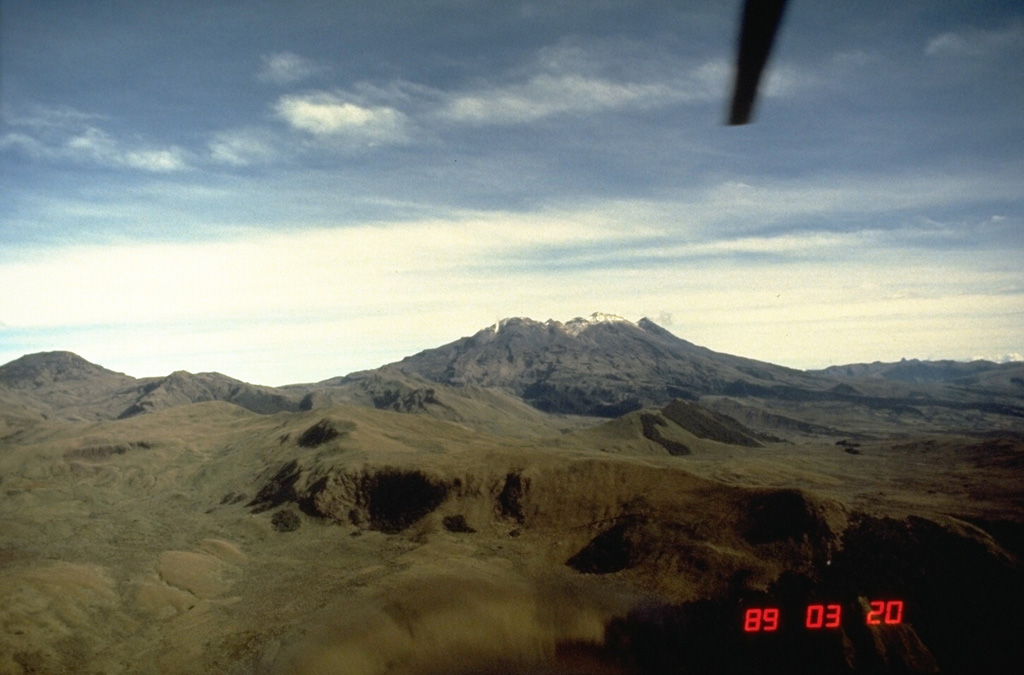
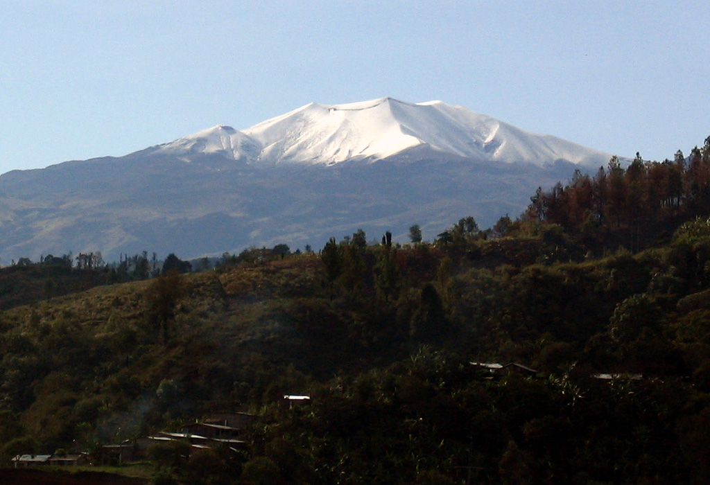
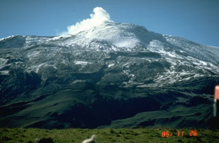
 Nevado del Ruiz is a broad glacier-covered volcano that covers more than 200 km2. The modern cone consists of a cluster of lava domes constructed within the summit caldera of an older edifice. The ash-mantled summit is seen here from the ESE on 18 December 1985, a little more than a month after the catastrophic eruption of 13 November. The devastating 1985 lahars swept down four major river drainages that day and caused around 24,000 fatalities.
Photo by Norm Banks, 1985 (U.S. Geological Survey).
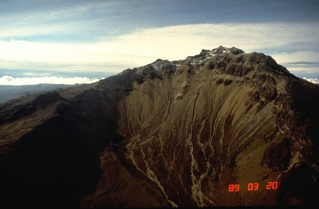
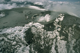
 A large cone fills much of the large collapse scar at Galeras. It is seen degassing here on 18 March 1989 from the SE. The El Viejo flank crater can be seen near the center of the photo, with the Bastón fissure to the right, just below the rim of the main crater. The central cone has been the site of frequent eruptions since the time of the Spanish conquistadors.
Photo by Norm Banks, 1989 (U.S. Geological Survey).
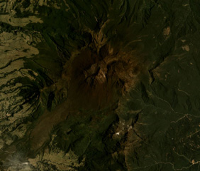 The Doña Juana complex in Colombia is shown in this September 2017 Planet Labs satellite image monthly mosaic (N is at the top; this image is approximately 8 km across). The summit area is shaped by a large scarp that has been infilled by lava domes, which have subsequently undergone collapse events to produce block-and-ash flow deposits.
Satellite image courtesy of Planet Labs Inc., 2017 (https://www.planet.com/).
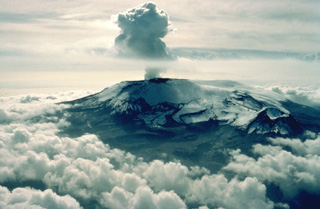
 Two weeks after the 13 November 1985 eruption, a plume rises from Las Arenas, the summit crater of Nevado del Ruiz. This view from the NNW shows pyroclastic surge and pyroclastic flow deposits mantling the summit icecap. Grooves descending the upper glacier surface were scoured by pyroclastic surges, which reached 5.5 km NW and NE of the summit. Melting of the summit icecap during the eruption led to devastating lahars that traveled as far as 100 km from the volcano and caused 24,000 fatalities.
Photo by Norm Banks, 1985 (U.S. Geological Survey).
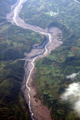 This aerial view of the Río Páez, with flow direction to the top, shows the path of the November 2008 lahars. The village at upper right is Mesa de Caloto, SSW of Huila. An eruption on November 20, 2008 destroyed part of the new lava dome, and hot material melted areas of the surrounding glacier and caused lahars in the Bellavista and Páez rivers, damaging infrastructure and destroying homes along the Río Páez.
 Photo by Tom Pierson, 2010 (USGS, Cascades Volcano Observatory).
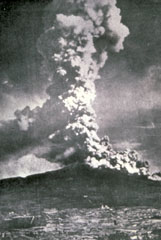
 The catastrophic 1985 eruption of Nevado del Ruiz began with moderate phreatic explosions on September 11. On November 13 a relatively moderate explosive eruption occurred, producing pyroclastic flows and surges that melted part of the summit icecap. These caused major lahars that devastated Amero and other towns on the flanks of the volcano, killing more than 23,000 people. Intermittent minor ash emissions, such as this one on November 28, and occasional stronger phreatomagmatic eruptions continued until July 1991.
Copyrighted photo by Katia and Maurice Krafft, 1985.
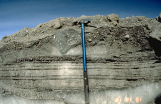 A record of the 13 November 1985 eruption of Nevado de Ruiz was preserved in ice-rich levees of pyroclastic flows. This photo, taken a month later, shows parallel-bedded pyroclastic-surge deposits, composed of snow grains and tephra, which were deposited over a pre-existing ice at the bottom of the photo. The surge layers are overlain at the top by coarser-grained pyroclastic-flow deposits. The clast of glacial ice (located left of the upper part of the ice axe) was scoured and incorporated into the pyroclastic flow.
Photo by Tom Pierson, 1985 (U.S. Geological Survey).
 Cerro Negro de Mayasquer is the youngest of a pair of twin volcanoes along the Ecuador-Colombia border. It is seen here from the Ecuadorian side on the south. The long ridge to the left of its summit is the rim of a horseshoe-shaped caldera that is breached to the NW.
Photo by Minard Hall, 1985 (Escuela Politécnica Nacional, Quito)
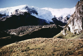
 Santa Isabel is a small glaciated volcano is seen here from its much larger neighbor to the NE, Nevado del Ruiz. Holocene lava flows fill SW and SE valleys. A small Holocene lava dome was emplaced about 10 km SW of the volcano.
Photo by Norm Banks, 1985 (U.S. Geological Survey).
 Azufral stratovolcano in southern Colombia, seen here from the SE, is also known as Azufral de Túquerres. It is truncated by a 2.5 x 3 km caldera containing a Holocene lava dome complex. A crescent-shaped lake, Laguna Verde, occupies the NW side of the caldera. Nearly a dozen lava domes are present, the latest of which were formed about 3600 years ago and have active fumaroles. The last known eruption of Azufral volcano took place about 1000 years ago.
 Photo by Norm Banks, 1989 (U.S. Geological Survey).
 Cumbal is the southernmost historically active volcano of Colombia. It is seen here from the north, with a young lava dome occupying the 150-m-wide summit crater. Flank craters, the youngest of which is Boca de Mundo Nuevo, have formed along radial fissures on the east and south flanks of the nearly symmetrical volcano. Eruptions from the upper east flank produced a 6-km-long lava field. Explosive eruptions in 1877 and 1926 are the only known historical activity from Cumbal.
 Photo by Norm Banks, 1989 (U.S. Geological Survey).
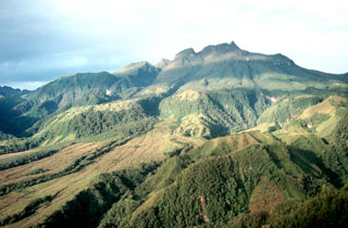
 Galeras, a stratovolcano with a large breached caldera located immediately west of the city of Pasto, is one of Colombia's most frequently active volcanoes. It is seen here from the south on March 17, 1989, with steam clouds pouring from vents on the large central cone near the back headwall of the caldera, whose south rim forms the ridge in the foreground. Major explosive eruptions since the mid Holocene have produced widespread tephra deposits and pyroclastic flows that swept all but the southern flanks.
 Photo by Norm Banks, 1989 (U.S. Geological Survey).
 An ash plume from the summit crater of Galeras volcano rises above the city of Pasto on May 5, 1989. Intermittent phreatic explosions ejected ash and blocks from the El Pinta vent beginning on February 19. Periods of stronger activity took place on March 26-27 and May 4-9. The May activity produced pyroclastic surges near the crater.
Photo by Norm Banks, 1989 (U.S. Geological Survey).
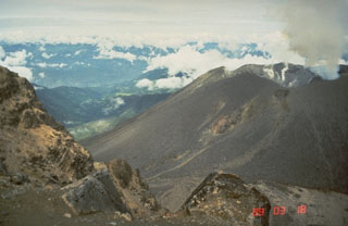
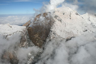 A dark, steaming lava seen from the east was emplaced during an eruption from Huila volcano that began in 2008. Pico del Sur lies at the left, with glacier-covered Pico Central at upper right and Pico Norte at far right. The lava dome straddled the summit ridge and descended opposite sides of the volcano. A major lahar in November 2008 swept down the Rio Paez, causing extensive damage. Long-term ome growth and periodic ash emissions continued.
Photo by Tom Pierson, 2010 (USGS, Cascades Volcano Observatory).
 Nevado del Huila is an elongate, N-S-trending glaciated edifice constructed within an old caldera, seen here from the SW. The northern peak (La Cuesta) is to the left and the lower southern peak to the right is Pico Central.
Photo by Juan Carlos Diago, 1995 (courtesy of Bernardo Pulgarín, INGEOMINAS, Colombia).
 Snow-capped Puracé volcano has a 500-m-wide summit crater and is one of the most active volcanoes in Colombia. Frequent explosive eruptions in the 19th and 20th centuries have modified the morphology of the summit crater, with some of the largest occurring in 1849, 1869, and 1885.
Photo by Federmán Escobar Chávez, 2005.
 The summit of Cerro Negro de Mayasquer volcano is truncated by a caldera that is breached to the west. This view from the NW shows snow-capped Volcán Chiles at the upper left. Eruptive activity at these twin volcanoes has migrated to the west, with the most recent eruptions occurring from Cerro Negro de Mayasquer. A small crater lake is found at the bottom of the 900 x 1500-m-wide caldera. An eruption that was reported from the volcano in 1936 may actually have been from Reventador volcano to the SE.
Photo by Minard Hall, 1985 (Escuela Politécnica Nacional, Quito)
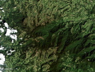 Romeral volcano forms the area in the center of this 24 January 2018 Sentinel-2 satellite image, NE of the city of Manizales (N is at the top; the image is approximately 19 km across). It produced two Plinian pumice eruptions that blanket areas NW of the volcano, and is located at the northern end of the Ruiz-Tolima volcanic chain.
Satellite image courtesy of Copernicus Sentinel Data, 2018.
 Two central lava domes of Cerro Machín volcano are seen here from the SW. A 3-km-wide caldera, whose rim is the horizontal change in slope across the center of the photo, opens towards the south. Late-Holocene eruptions produced block-and-ash flows that traveled to the west and south, beyond the caldera. Deposits from some of these eruptions form the eroded slopes in the lower part of the photo along the valley of the Toche River.
Photo by José Macías, 1996 (Universidad Autómona de México).
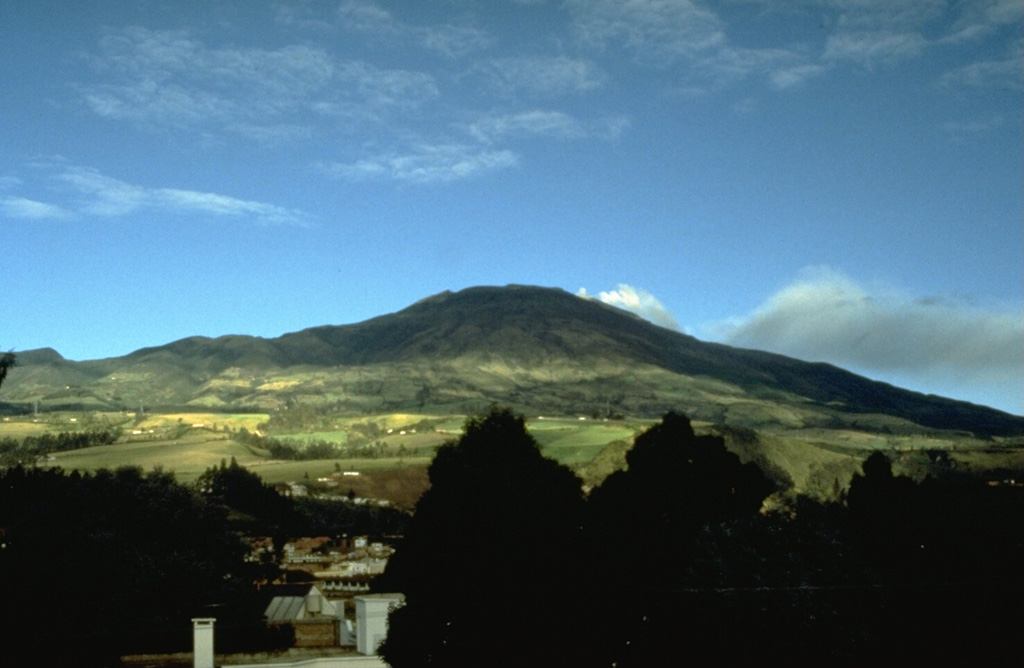
 Galeras, one of the most active volcanoes of Colombia, rises west of the city of Pasto. The high point is the eastern rim of a large caldera that is breached to the west and serves to funnel most of the eruptive products of the volcano away from the city. Larger explosive eruptions during historical time have produced pyroclastic flows that overtopped the caldera rim.
Photo by John Ewert, 1989 (U.S. Geological Survey).
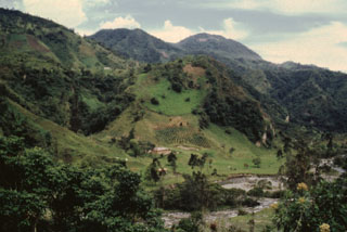 The terraces along the Toche River are composed of thick pyroclastic flow deposits produced during Holocene explosive eruptions of Cerro Machín. The summit lava domes are seen on the horizon in this view from the NNW. This small but explosive volcano is located at the southern end of the Ruiz-Tolima massif.
 Photo by José Macías, 1996 (Universidad Autómona de México).
 Cerro Negro de Mayasquer (Ieft) and snow-capped Volcán Chiles (right), seen here from the south, are twin volcanoes that straddle the Colombia-Ecuador border. Chiles volcano is of Pleistocene age, but has hot springs and an active hydrothermal system on its eastern flank. Cerro Negro de Mayasquer is a stratovolcano with a caldera open to the west. Andesitic and dacitic lava flows are of possible Holocene age. Solfataras are found on the shore of a small crater lake.
 Photo by Minard Hall, 1985 (Escuela Politécnica Nacional, Quito)
 On 13 November 1985 lahars traveled down the upper Guali River drainage on the N flank of Nevado del Ruiz, seen here descending diagonally from right of center to the lower left. Farmhouses are visible on the opposite side of the channel for scale. The lahars traveled down the Río Guali at velocities up to 17 meters/second to over 100 km from the volcano.
Photo by Tom Pierson, 1985 (U.S. Geological Survey).
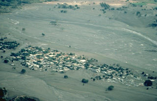 The 1985 eruption of Colombia's Nevado del Ruiz volcano produced the deadliest lahars (volcanic mudflows) in recorded history. A relatively moderate explosive eruption melted parts of the summit icecap and sent lahars down four major drainages. The town of Armero, shown here, was destroyed by a lahar that had traveled 74 km east of the summit and exited a narrow canyon above the town in a 40-m-high wave. Three-quarters of the 28,000 inhabitants of Armero were killed because officials and residents were not prepared for the danger the volcano posed.
Copyrighted photo by Katia and Maurice Krafft, 1985.
 On August 27, 1936, a vigorous explosive eruption took place from Galeras volcano. Photographs taken from Pasto show pyroclastic flows descending the NE flank to distances of 3-4 km from the summit. The timing of eruptive activity in 1936 is ambiguous, but evidence does exist for an eruption on February 9 that produced explosions, the ejection of incandescent bombs, and an ash plume.
 Photo courtesy of Marta Calvache, 1936 (INGEOMINAS-Observatorio Vulcanológico del Sur).
 Cerro Bravo in Colombia is seen to the north from the N flank of Nevado del Ruiz. The CB1 summit dome rises above an older dome and cone complex, probably produced during the CB7-CB5 eruptive periods. Below this, the remains of the pre-Cerro Bravo volcano encompass the Pleistocene Quebrada Seca caldera. Most of the Pleistocene lava flows in the foreground are associated with Nevado del Ruiz.
Photo by David Lescinsky, 1988 (University of Western Ontario).
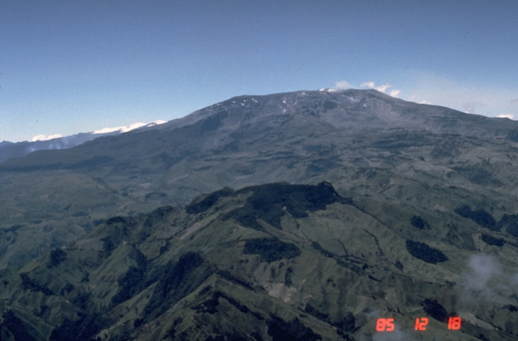
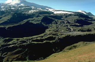
 The glacier on Nevado del Ruiz is seen here above the Azufrado valley on the NE flank. Debris avalanche deposits from an eruption roughly 3,100 years ago, and from the 1595 eruption, appear in the foreground. The major eruption about 3,100 years ago produced a large ashfall deposit, the debris avalanche, and associated lahars and pyroclastic surges. The 1595 eruption, the largest from Ruiz in historical time, was similar. Lahars in 1595 caused over 600 fatalities.
Photo by Jean-Claude Thouret (Université Grenoble).
 Sotará in Colombia is shown in the center of this February 2020 Planet Labs satellite image monthly mosaic (N is at the top; this image is approximately 19 km across). The edifice formed within a 4.5-km-diameter caldera and has a collapse scarp open towards the SW, as well as several lava domes in the summit area. Thick lava flows and domes have been emplaced within the scarp.
Satellite image courtesy of Planet Labs Inc., 2020 (https://www.planet.com/).
 A plume rises from the summit crater of Nevado del Ruiz volcano on 10 December 1985. Pyroclastic surge and ashfall deposits from the 13 November eruption coat the glaciers. Glaciers on the upper NE-flank headwall of the Azufrado valley (foreground) were scoured by pyroclastic surges.
Photo by Tom Pierson, 1985 (U.S. Geological Survey).
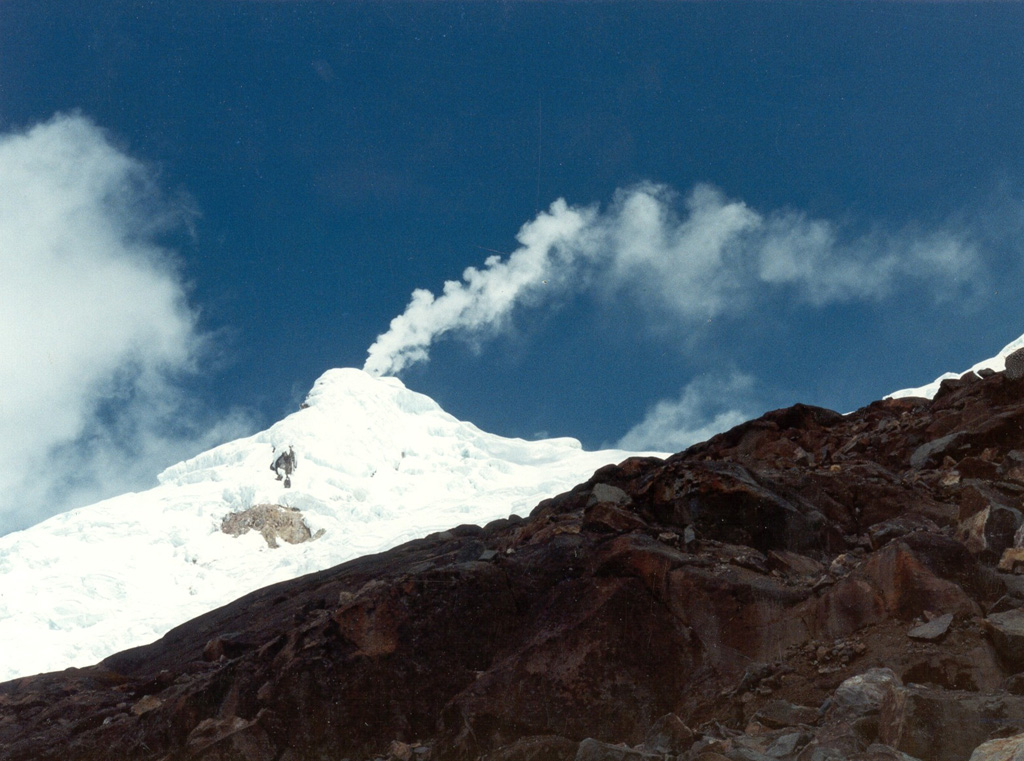
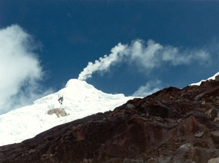 A gas plume rises above the glaciated Nevado del Huila Pico Central, seen here from the east in September 1996. Long-term, persistent, gas plumes occurred prior to the onset of eruptive activity in 2007. Before then, only a single 16th century eruption was known during historical time.
Photo by Bernardo Pulgarín, 1996 (INGEOMINAS, Colombia).
This is a compilation of Colombia volcano information sources, such as official monitoring or other government agencies.
| Volcanic Ash Advisory Center | |
|---|---|
| Washington Volcanic Ash Advisory Center (VAAC) | |
| - Washington VAAC Archive | |
| - Washington VAAC Notices | |